Land
United States |
Zillow
There are several comprehensive land ownership databases for land in
the United States, each offering nationwide parcel data, ownership
information, and property boundaries:
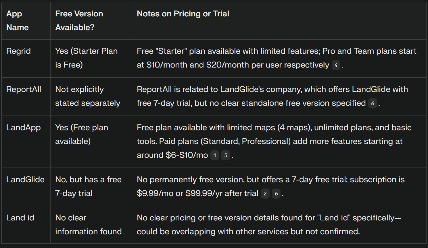
Regrid provides 100% land parcel
coverage for the U.S., with property boundaries, owner details, and
exportable data for every county.
ReportAll
covers over 99% of
the U.S. with standardized parcel data updated daily, including
property boundaries and ownership information.
LandApp
offers land ownership data, property boundaries, owner
names, contact info, and sales history for over 150 million parcels
nationwide.
LandGlide
accesses over 157 million parcel records in more than 3,200
counties, providing owner names, addresses, parcel boundaries, and
more.
Land id™ (formerly
MapRight): Delivers nationwide ownership info, property boundaries,
and extensive land data layers for real estate, agriculture, and
more. It offers a 7-day free trial for all new users. It emphasizes
that map creation, data overlays, and sharing features are part of
the paid tiers, making the free trial mainly a way to test the full
suite before committing financially.
The platform provides
several subscription options:
Land id Discover: For basic
property data access, around $79.99/year.
Land id Basic:
$7/month, billed annually.
Land id Premium: $12/month, billed
annually.
Land id Pro: $33.33–$66.67/month, billed annually, for
professional and enterprise users.
Cotality
features detailed U.S. property data, including parcel boundaries,
ownership, land use, tax data, and more.
- Land use and tax data allows you
to understand current zoning, property tax burdens, and how the land
is currently
classified, which directly impacts its potential use
and future value. |
 |
Billy
Land specializes in affordable owner-financed rural land sales
across the U.S. with a process involving bidding as a down payment,
followed by financing on the remainder. It has mostly positive
customer feedback for professionalism and helpfulness.
It offers
owner-financed land for sale across the United States, featuring
parcels in multiple states including Colorado, Oregon, Alaska, and
Florida. Their inventory includes some of the cheapest residential
quality land available, with currently hundreds of parcels listed
across dozens of counties and states. The company acquires large
tracts of land at reduced costs, enabling them to offer affordable
prices with owner financing options.
The buying process
involves bidding on parcels, where the bid counts as a down payment,
with financing arranged for the remainder. Customer reviews indicate
generally positive experiences with professional and helpful staff
guiding buyers through the process. Some buyers have noted ease in
purchasing land with affordable payments and prompt deed delivery.
However, some caution exists about repeated parcel listings if
buyers fail to complete payments.
It operates during regular
business hours and offers support to new users who want to bid and
purchase land. The company also has an active online presence where
users share their buying experiences.
Land Limited provides a
simple way for people to buy land online, with listings that include
property details such as acreage, price, location, and access
features like paved roads or power availability. This company
specializes in buying and selling land online, particularly rural
and vacant properties. They have over 30 years of combined
experience helping buyers find and finance land, offering
straightforward, stress-free transactions with no hidden fees. Their
website features a variety of properties for sale across the United
States, ranging from small lots to large acreage, with options for
easy financing. Customers praise the platform for its ease of use,
transparent pricing, and excellent customer support.
Bureau of Land
Management (BLM) Land Records offers federal land records,
including historical documents and interactive mapping tools, mainly
for federal lands.
These platforms are the most comprehensive
sources for U.S. land ownership data, with varying features and
coverage. For most users seeking nationwide, parcel-level data with
ownership details, Regrid, ReportAll, LandApp, and LandGlide are
leading options.
Property Boundaries & Ownership: Platforms
like
Regrid,
ReportAll,
LandApp, LandGlide, and Land id™
provide crucial parcel boundaries and ownership details.
You
can use this to verify the exact parcel being auctioned, confirm the
listed owner, and understand the surrounding land use. This is
critical for rural properties where boundaries can be less obvious.
Sales History & Contact Info:
LandApp specifically mentions sales history and owner contact
info. You can flag properties with a long ownership history
(potential for motivated sellers) or recent quick flips (potential
for profit patterns). Having contact info for FSBO (For Sale By
Owner) or absentee owners is invaluable for off-market deals.
These databases open doors to "off-market" opportunities.
Identify Distressed Properties: By cross-referencing tax data
(e.g., properties with high tax delinquency flags from a county
website) with these parcel databases, you can identify properties
ripe for tax sales or direct outreach before they even hit an
auction.
Target Absentee Owners: Many cheap rural properties
are owned by people who live elsewhere and might be motivated to
sell if approached directly. Your AI could combine scrape data
(e.g., looking for properties with out-of-state owner addresses from
public tax records) with these databases to generate targeted leads
for you.
Assess Rehabilitation Potential: Knowing the exact
parcel boundaries and neighboring land use (from Land id™ or
Cotality) can help your AI gauge if a property is suitable for
minimal rehab. For example, it could flag parcels near existing
utilities or roads, or ones that seem unencumbered for basic
development.
Specific Database
Relevance:
For Nationwide Parcel Data (Crucial for AI
Scraping/Analysis): Regrid,
ReportAll,
LandApp, LandGlide, and
Cotality
appear to be the most relevant. They offer standardized,
comprehensive data.
For Federal Land Opportunities: The
Bureau of Land
Management (BLM) Land Records would be directly relevant if
you're also interested in federal lands or historical federal
transactions impacting nearby private land.
For Broader
Market Understanding: While not directly for finding individual
parcels, Land
Matrix and Land Mark
offer insights into global land trends and community ownership,
which could inform your overall understanding of land values and
potential socio-political factors in certain regions if your scope
ever expands.
Considerations for AI Integration:
API
Access and Cost: Many of these comprehensive databases (Regrid,
ReportAll,
LandApp, LandGlide, Land id
™, Cotality)
are commercial services. They offer APIs for programmatic access,
which is essential for an AI system, but these APIs almost certainly
come with significant subscription fees, especially for nationwide,
high-volume data access. This would be a crucial investment.
Data Formats and Standardization: Even with APIs, the data might not
be perfectly uniform across all providers.
Refresh Rates:
How often is the data updated? For fast-moving auction
opportunities, near real-time updates are critical.
Licensing
and Terms of Service: Be aware of the terms of service for any data
you programmatically access. Most commercial databases have strict
rules against redistribution or large-scale re-use without
appropriate licenses. |
|
Worldwide |
No single database currently provides a fully comprehensive,
real-time, parcel-level view of all land ownership worldwide due to
privacy laws, fragmented records, and varying government
transparency. For global-scale analysis of large land deals, Land
Matrix is the most comprehensive open-access resource. For
indigenous and community lands, LandMark is the leader. For
parcel-level mapping, Regrid is notable for its global ambition but
is still a work in progress
Here are the most comprehensive
land (ownership) databases in the world, each with its focus and
direct online access:
Land
Matrix, a leading open-access database on large-scale land
acquisitions globally, promotes transparency and accountability in
land deals. It is widely recognized as one of the most comprehensive
open-access databases for large-scale land acquisitions worldwide.
Since 2012, it has systematically collected and verified data on
over 1,700 concluded deals, covering more than 50 million hectares
in over 85 countries. The Land Matrix focuses specifically on
transparency and accountability in large-scale land deals, making it
the leading global resource for this type of land ownership data.
Land Mark, the global
platform for mapping indigenous and community lands, consolidating
georeferenced data on collectively-held territories worldwide,
offers a global platform for mapping indigenous and community lands,
consolidating data from local, national, and regional sources to
provide georeferenced information on collectively-held lands
worldwide.
Regrid (formerly
LOVELAND Technologies), an ambitious project to map every property
parcel, currently offering comprehensive parcel data coverage for
the United States and expanding globally, is building a global
parcel database, aiming to map every parcel of property on the
planet. While ambitious, its coverage is still expanding and may not
yet rival the depth of national cadastral systems in every country.
National
Cadastre and Land Registries remain the most authoritative
sources for detailed, parcel-level land ownership data, but access,
openness, and comprehensiveness vary greatly by country. Some
countries make this data public and updated regularly, while others
restrict access or charge fees. They are the authoritative sources
for parcel-level land ownership information within individual
countries. For the
Each of these resources is the most
comprehensive in its respective domain—global land deals,
indigenous/community lands, parcel-level mapping, and national
registries. No single database covers all land ownership worldwide
at the parcel level due to differences in national laws and data
access. |
Back
to Mike Beaver's Hypnotherapy Home Page
|
|
If you are the original creator of material featured on this website and want
it removed, please contact the webmaster.
Copyright © 1998-2006
Charles Michael Beaver.
|